There were 9 Questions from Geography in 2022, of which
- 1 Question on Fundamentals of Physical Geography
- 3 Questions on Indian Physical Geography
- 3 Questions on World Physical Geography
- 2 Questions on Economic Geography
Most of the questions were aimed at testing the conceptual clarity and understanding of map.
Overall, the level of the questions was easy to moderate.
Previous Year UPSC Geography Questions (PYQs) With Explanation 2022
1. Which one of the following lakes of West Africa has become dry and turned into a desert?
(a) Lake Victoria
(b) Lake Faguibine
(c) Lake Oguta
(d) Lake Volta
1. Ans: b
Explanation:
The Faguibine system, located in the Tombouktou region in Mali, is a series of five interlinked lakes (Télé, Takara, Gouber, Kamango and Faguibine). The system is fed from the overflows of the Niger River during the rains; and when full, it was among the largest lakes in West Africa, covering approximately 590 km with a total shoreline of 213 kilometres.
In the late 19th century, the floodplain extended over an area of 1,000 km–, however, declining rainfall led to it shrinking to about 90 km² by 2010. Prolonged droughts over the years also led to the lake completely drying up in 1914, 1924 and 1944.
The decline of the Faguibine is an important issue because of its impacts on livelihoods, food security and the resulting collapse of the natural ecosystem.
Hence, option b is correct.
2. Gandikota canyon of South India was created by which one of the following rivers?
(a) Cauvery
(b) Manjira
(c) Pennar
(d) Tungabhadra
2. Ans: c
Explanation:
The Pennar (also known as Uttara Pinakini) is one of the major rivers of the peninsula.
Pennar River rises from the Chenna Kesava hills of the Nandi ranges of Karnataka and flows for about 597 km before outfalling into the Bay of Bengal. The Principal tributaries of the river are the Jayamangal, the Kunder, the Sagileru, the Chitravati, the Papagni and the Cheyyeru.
Gandikota village, located in Kadapa district, Andhra Pradesh, is home to a stunning canyon, by the Pennar river.
Over time, the Pennar River carved the pink granite rock of Erramala Hills and formed Gandikota Canyon.
Gandikota Canyon has been an important part of Andhra Pradesh’s history. From the Kakatiyas and Vijayanagaras to the Qutub Shahis.
Hence, option c is correct.
3. Consider the following pairs:
Peak Mountains
Namcha Barwa : Garhwal Himalaya
Nanda Devi : Kumaon Himalaya
Nokrek : Sikkim Himalaya
Which of the statements given above is/are correctly matched?
(a) 1 and 2
(b) 2 only
(c) 1 and 3
(d) 3 only
3. Ans: b
Explanation:
The Eastern Himalayas
Also known as the Assam Himalayas, the Eastern Himalayas lie between the Tista River in the west and the Brahmaputra River in the east. It mainly occupied the areas of Arunachal Pradesh and Bhutan. The prominent peaks of this area are Namcha Barwa (7,756 m), Kula Kangri (7,554 m), Chamo Lhari (7,327 m), Hozin Kang Sa (7,252 m), Gyalaperi and Kangto.
Hence, 1st pair is incorrectly matched.
The Kumaon Himalayas
Between the Satluj and the Kali rivers is the 320 km long Kumaon Himalayas. Its western part is called Garhwal Himalayas while the eastern part is known as Kumaon Himalayas. Nanda Devi (7,817 m), Kamet (7,756 m), Trisul (7,140 m), Badrinath (7,138 m), Kedarnath (6,968 m), Gangotri (6,510 m) are important peaks. The sources of sacred rivers like the Ganga and the Yamuna are located in the Kumaon Himalayas.
Hence, 2nd pair is correctly matched.
Nokrek is the highest peak in the West Garo Hills of Meghalaya. Nokrek (Meghalaya) have been included in the World Network of Biosphere Reserves of UNESCO.
Nokrek is not situated in Sikkim Himalaya.
Hence, 3rd pair is incorrectly matched.
4. The term “Levant” often heard in the news roughly corresponds to which of the following regions?
(a) Region along the eastern Mediterranean shores
(b) Region along North African shores stretching from Egypt to Morocco
(c) Region along the Persian Gulf and Horn of Africa
(d) The entire coastal areas of the Mediterranean Sea.
4. Ans: a
Explanation:
The Levant is a historical term referring to a large area in the Eastern Mediterranean. This region includes modern-day Levant countries such as Syria, Lebanon, Jordan, Israel, Palestine, and parts of Turkey. In some contexts, Cyprus and parts of Iraq are also considered part of the Levant.
The region stretches from the eastern Mediterranean coast to the deserts of the Arabian Peninsula, bordered by the Taurus Mountains to the north and the Arabian Desert to the south.
The Levant is often called the “cradle of civilisation” because it is home to some of the earliest human settlements.
The Levant’s location at the crossroads of three continents(Africa, Asia, and Europe.) has made it a strategic area for military and political power.
The ongoing conflict between Palestinians and Israelis is centered in the Levant. The Gaza Strip and the West Bank are both part of the Levant. The conflicts in Levant countries such as Syria and Israel have global implications.
Hence, option a is correct.
5. Consider the following countries:
1. Azerbaijan
2. Kyrgyzstan
3. Tajikistan
4. Turkmenistan
5. Uzbekistan
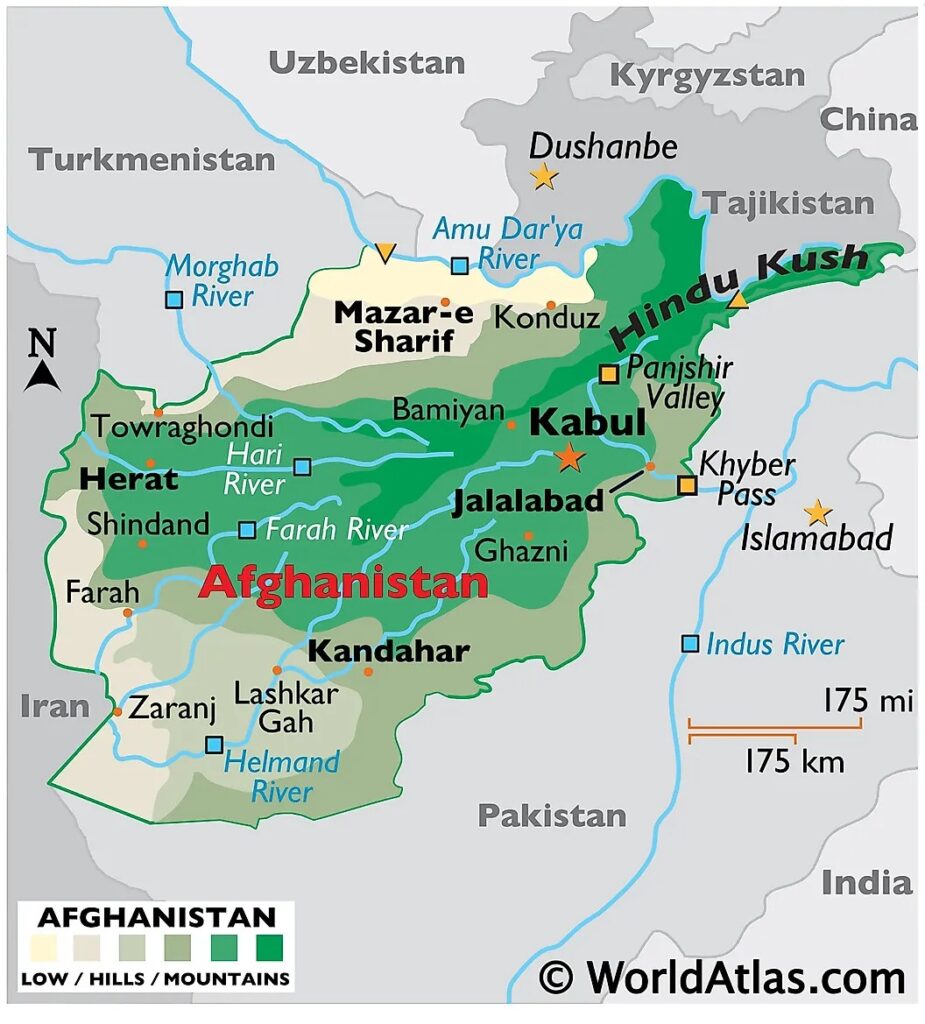
Which of the above has borders with Afghanistan?
(a) 1, 2 and 5 only
(b) 1, 2,3 and 4 only
(c) 3, 4 and 5 only
(d) 1, 2, 3, 4 and 5
5. Ans: c
Explanation:
Afghanistan is a landlocked mountainous country in Southern Asia. It is bordered by six nations – Pakistan in the east and south, Iran in the west, Turkmenistan, Uzbekistan and Tajikistan in the north and China in the northeast.

Hence, option c is correct.
6. With reference to India, consider the following statements:
1. Monazite is a source of rare earths.
2. Monazite contains thorium.
3. Monazite occurs naturally in the entire Indian coastal sands in India.
4. In India, Government bodies only can process or export monazite.
Which of the statements given above are correct?
(a) 1, 2 and 3 only
(b) 1, 2 and 4 only
(c) 3 and 4 only
(d) 1, 2, 3 and 4
6. Ans: b
Explanation:
The coastal region of peninsular India contains economically important minerals such as garnet, ilmenite, leucoxene, monazite, rutile, sillimanite and zircon commonly known as beach sand minerals.
Hence, statement 1 is correct.
Thorium is mainly obtained from monazite and ilmenite in the beach sands along the coast of Kerala and Tamil Nadu.
Hence, statement 2 is correct.
World’s richest monazite deposits occur in Palakkad and Kollam districts of Kerala, near Vishakhapatnam in Andhra Pradesh and Mahanadi river delta in Odisha.
Hence, statement 3 is incorrect.
Indian Rare Earths Limited (IREL), a wholly owned Public Sector Undertaking of the Government of India (GOI) under DAE, is the only entity which has been permitted to produce and process monazite, and handle it for domestic use as well as for export.
A license from the Department of Atomic Energy (DAE) under the Atomic Energy (Working of the Mines, Minerals and Handling of Prescribed Substances) Rules 1984 promulgated under the Atomic Energy Act 1962 is necessary for exporting monazite.
Hence, statement 4 is correct.
7. In the northern hemisphere, the longest day of the year normally occurs in the :
(a) First half of the month of June
(b) Second half of the month of June
(c) First half of the month of July
(d) Second half of the month of July
7. Ans: b
Explanation:
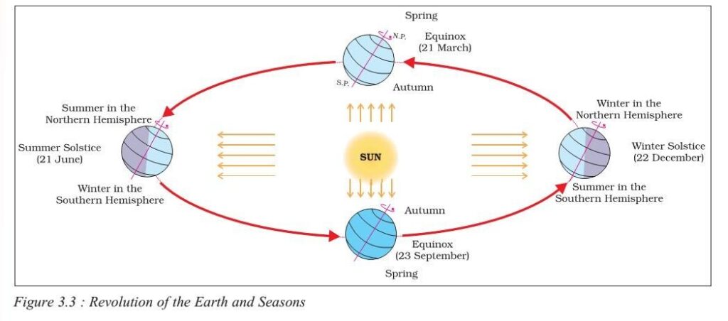
21st of June every year marks the summer solstice of the Northern hemisphere (winter solstice in the Southern hemisphere). On this day the Earth travels the longest path in the sky, hence making it the longest day of the year.
Aphelion is the day when the Earth is farthest from the sun. It typically occurs ‘after 14 days from Summer solstice’ and not on the same day.

Hence, option b is correct.
8. Consider the following States:
1. Andhra Pradesh
2. Kerala
3. Himachal Pradesh
4. Tripura
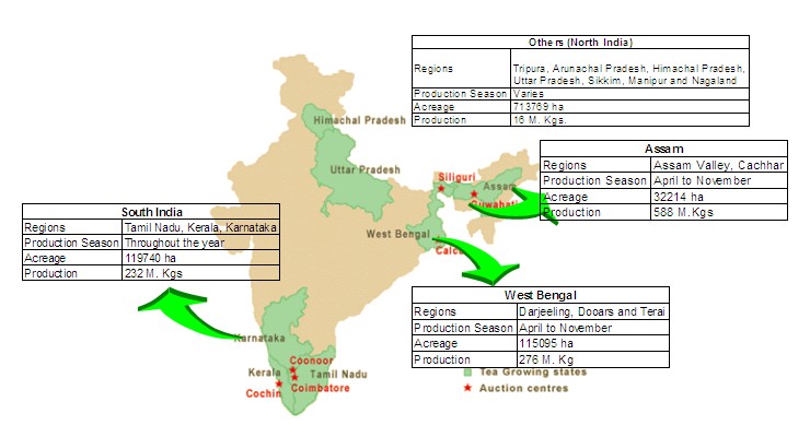
How many of the above are generally known as tea-producing States?
(a) Only one State
(b) Only two States
(c) Only three States
(d) All four States
8. Ans: d
Explanation:
As per the India Tea Association, tea-growing regions are- Tripura, Arunachal Pradesh, Himachal Pradesh, Uttar Pradesh, Sikkim, Manipur, Nagaland, Assam, West Bengal, Tamil Nadu, Kerala and Karnataka.
Andhra Pradesh, though not a major tea-producing state, tea is cultivated in the Araku valley of the state.

Hence, option d is correct.
9. Consider the following pairs:
Reservoirs States
1. Ghataprabha — Telangana
2. Gandhi Sagar — Madhya Pradesh
3. Indira Sagar — Andhra Pradesh
4. Maithon — Chhattisgarh
How many pairs given above are not correctly matched?
(a) Only one pair
(b) Only two pairs
(c) Only three pairs
(d) All four pairs
9. Ans: c
Explanation:
Ghatprabha Reservoir is situated in the Belgavi district of Karnataka. Ghatprabha is a major tributary of River Krishna.
Hence, 1st pair is incorrectly matched.
Gnadhisagar Reservoir is built upon the Chambal River in Mandsaur district of Madhya Pradesh. The reservoir created by the related dam is the third largest in India (after the Indirasagar Reservoir and Hirakud Reservoir). It is one of the four major dams built on India’s Chambal River, the others being the Jawahar Sagar, Rana Pratap Sagar, and Kota Barrage.
Hence, 2nd pair is correctly matched.
Indira Sagar Reservoir is located on the Narmada River in Khandwa district of Madhya Pradesh. It is the largest reservoir of India.
Hence, 3rd pair is incorrectly matched.
The Maithon Dam is located in Jharkhand. Maithon derived its name from “Mai Ka Sthan”, meaning the place for the Hindu Goddess Maa Kalyaneshwari. It is located on the banks of river Barakar. The Maithon Dam is located about 48 km from the Coal City of Dhanbad.
Hence, 4th pair is incorrectly matched.


